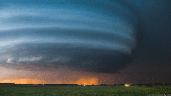
Very strong thunderstorms are expected over parts of southern Colorado late Thursday afternoon and evening. Some severe weather days are more significant than others and today is one of those days. Supercell thunderstorms developing after 3pm will move to the southeast into the evening, eventually developing into a cluster or broken line of storms.
While the storms are on their own away from other storms, the greatest severe weather risk will be very large hail and tornadoes, in addition to flooding rains. Later in the evening over the eastern plains the tornado threat may drop a little as the threat for straight-line wind increases.
The white hatched area indicated areas with potential for significant hail larger than 2″ in diameter
The bright red shading shows the highest potential for tornadic thunderstorms over southern Colorado
There were several reports of 3″ diameter hail over the plains Wednesday evening around Manzanola and in La Junta. The strongest storms today may produce hail larger than 3″ in diameter. The tornado threat is about as high as it gets over eastern Colorado today – we aren’t talking weak landspout tornadoes – we are talking about the potential for a moderate to strong tornado underneath the supercells.
Storms are expected to form after 3pm over the terrain features west of I25 and over the Palmer Divide. While they are likely to become strong rapidly as they develop, the largest hail and greatest risk of tornadoes will be as the storms move toward highway 50.
WATCH VS. WARNING – KNOW THE DIFFERENCE
A severe thunderstorm or tornado WATCH is often issued ahead of the first storm developing. A watch means that ingredients are in place for the development of strong to severe thunderstorms over the next several hours. Watches are often issued for up to six or eight hours and are issued for multiple counties. When a WATCH is issued you should review your severe weather plan and stay alert to your FOX21 Storm Team app, FOX21 on television, NOAA weather radio, or other ways to get weather information.
A severe thunderstorm or tornado WARNING is issued when a storm is producing severe weather or is expected to do so at any moment. When a WARNING is issued you should take action and implement your severe weather plan at your home or place of work.
Take the opportunity before storms form to review your severe weather plan, or create one if you haven’t. Where is the safest place where you are? Get away from windows during severe weather. Be ready to seek higher ground if water rises.

