TAMPA, Fla. (WFLA) — Hurricane Ian, now a Category 3 storm, is currently battering Cuba with strong winds and life-threatening storm surge as it makes its way toward the Tampa Bay area, the National Hurricane Center said in its latest advisory.
The NHC issued a hurricane warning for Tampa Bay Monday night. This means hurricane conditions (sustained winds of 74 mph or higher) are expected in the area sometime in the next 48 hours.
Several Tampa Bay area counties issued evacuation orders on Monday. Residents living in Zone A in Hillsborough County, Zone A in Manatee County, zones A, B and C in Pinellas County and in Level A in Sarasota County are affected.
The storm made landfall in La Coloma, Cuba at 4:30 a.m. Tuesday.
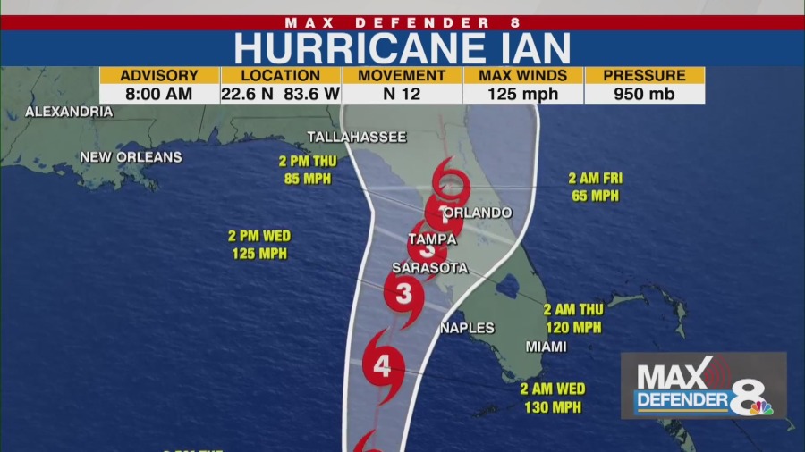
In its 8 a.m. advisory, the NHC said Ian was about about 130 miles south-southwest of the Dry Tortugas and about 10 miles north-northeast of Pinar del Río, Cuba, packing maximum sustained winds of 125 mph.
The storm was moving north at 12 mph with hurricane-storm-force winds extending outward up to 35 miles from its center, and tropical-storm-force winds extending outward up to 115 miles from the eye.
The eye of the storm should be near the country’s western coast Tuesday morning. The system should emerge over the southeastern Gulf of Mexico Tuesday and remain a major hurricane, according to the NHC. Some strengthening is expected.
The path would put Ian just west of the Florida Keys Tuesday evening and near the west coast of Florida in the hurricane warning area on Wednesday.
“This morning two of our forecast models, the GFS and European models, came closer to agreeing. Both models turn the storm earlier to the east, potentially making landfall somewhere between Pinellas and Sarasota counties late Wednesday into early Thursday,” said Storm Team 8 Meteorologist Leigh Spann.
The area could see 12 to 16 inches of rain with some areas seeing isolated amounts of up to 24 inches. The heavy rainfall could lead to considerable flash and urban flooding and prolonged river flooding. A few tornadoes will be possible across parts of Florida Tuesday and Wednesday, the NHC said.
Tampa Bay and other parts of Florida are also under a storm surge warning, meaning the storm could raise water levels above normal tides.
According to the NHC, water could reach the following heights above ground in the following areas:
Anclote River to Middle of Longboat Key, including Tampa Bay —5-10 ftSuwannee River to Anclote River — 5-8 ftMiddle of Longboat Key to Englewood, FL — 5-8 ftEnglewood, FL to Bonita Beach, including Charlotte Harbor —4-7 ftBonita Beach to Chokoloskee —4-7 ftChokoloskee to East Cape Sable —3-5 ftFlagler/Volusia County Line to Altamaha Sound including St. Johns River — 2-4 ftEast Cape Sable to Card Sound Bridge, including Florida Bay — 2-4 ftAucilla River to Suwannee River — 2-4 ftFlorida Keys, including the Dry Tortugas — 2-4 ftIndian Pass to Aucilla River — 1-3 ft
Here is a summary of watches and warnings in effect as of 8 a.m. Tuesday.
A Hurricane Warning is in effect for:
Cuban provinces of Isla de Juventud, Pinar del Rio, and ArtemisaBonita Beach to the Anclote River, including Tampa BayDry Tortugas
A Storm Surge Warning is in effect for:
Anclote River southward to FlamingoTampa Bay
A Tropical Storm Warning is in effect for:
Cuban provinces of La Habana, Mayabeque, and MatanzasLower Florida Keys from Seven Mile Bridge westward to Key WestFlamingo to Bonita BeachSuwannee River to the Anclote RiverVolusia/Brevard County Line south to Jupiter InletLake Okeechobee
A Storm Surge Watch is in effect for:
Florida Keys from the Card Sound Bridge westward to Key WestDry TortugasFlorida BayAucilla River to Anclote RiverAltamaha Sound to Flagler/Volusia County LineSaint Johns River
A Hurricane Watch is in effect for:
North of Anclote River to the Suwannee River
A Tropical Storm Watch is in effect for:
North of the Suwannee River to Indian PassAltamaha Sound to Volusia/Brevard County lineDeerfield Beach to Jupiter Inlet
Tracking Hurricane Ian
>> Latest updates on Hurricane Ian
>> Max Defender 8 Hurricane Guide
>> Download the Max Defender 8 app

