(CUSTER COUNTY, Colo.) — A geologist who has been working in the area of a rockslide that closed multiple highways in the McKenzie Junction area of Custer County said it is highly likely that additional rockslides could occur if slope mitigation is not performed in the area.
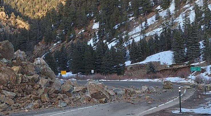
The intersection of Highway 96 and Highway 165 has been closed since Sunday, Dec. 29, after a large rockslide blocked all lanes of 96 and made the intersection of both highways impassable. Hwy 96 is closed from Wetmore to Westcliffe, and Hwy 165 is closed just northwest of Rye, with closures expected remain in place for several days.
Courtesy: Colorado Department of Transportation
Jay Temple, a geologist with the Colorado Geological Survey, surveyed the site on Monday, Dec. 30 and spoke with deputies from the Custer County Sheriff’s Office (CCSO). Temple said the rockslide likely happened because of fractures in a geological fault zone, which runs directly beneath McKenzie Junction.
“What has happened here is that we are on a major fault zone,” said Temple in a video shared by CCSO. “This fault zone runs right through the highway and goes right down at the intersection between Highway 96 and Highway 165, that goes up through Rye.”
Temple explained that the ILSE fault is an ancient fault zone that was active up to a billion years ago, though it is not currently a “tectonically active” fault. However, fractures associated with the fault accumulate water from snow melt, which causes land and rockslides. Temple explained that due to the steep slope above the highways, mitigation work is needed to keep more slides from happening and potentially putting drivers at risk.
“So what we’ve got to do here is ultimately, we’ve got to lower the slope here because there’s still abundant fractures up here and highly unstable slopes because of the degree of the face of the rock. And eventually at some point it will come down again,” Temple said.
Ultimately, what is needed may require explosives to even out the slope.
“Engineering probably with some dynamite, explosives to lower this slope to get this, this rock down on a little bit lower plane and move it back so that if there is another land slide, then it will not, hopefully, accumulate into the roadway.”
There is currently no estimated time of reopening of the roadways. While the highways are closed, detours are in place:
Western CO 96 Route:
North on CO 67 to US Highway 50
West on US 50 to CO 69
South on CO 69 to Westcliffe
Eastern CO 96 Route:
North on CO 69 to US 50
East on US 50 to CO 67
South on CO 67 to Wetmore
CO 165 Route:
South on CO 165 to Interstate 25
North on I-25 to CO 96
West on CO 96 to Wetmore

