Because most of us in southern Colorado live on the side of a fourteener with some pretty crazy elevation changes over short distances, forecast the weather is “fun!” Not only is getting the forecast correct quite tricky – it’s only 12 miles as the crow flies from the top of Pikes Peak (14,115′) to downtown Colorado Springs (~6,000′) – but communicating it when there is such variability from neighborhood to neighborhood is hard too!
Here’s a look at the forecast I showed Tuesday morning February 1, 2022 before the snow began. An upper level storm moving in from the west brought relatively warm and moist air from the eastern Pacific Ocean over the desert southwest into Colorado. This large scale lift brought snow to the entire viewing area. The varied terrain of our mountainous state always plays a role through on the smaller scale.
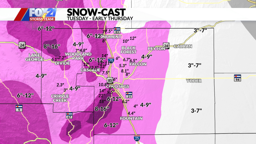
In the Pikes Peak Region, a southeast wind at the surface had me focusing on areas of the terrain that would benefit from some extra lift with that surface wind. The southeast flanks of Pikes Peak were likely to see the greatest benefit as the southeast wind is almost perpendicular to this area. It’s where I forecast the most snow – also to the northwest of Divide – where I forecast 8-16″. On the more general rise to the terrain in El Paso County, I forecast a general 4-9″ with less farther east.
The graphic below is my forecast for Pueblo, Cañon City, highway 50 over the plains and the southern foothills. The terrain was again the focus for the highest snow amounts with the combination of surface upslope and the larger scale lift. I did go with an area where I didn’t expect as much snow to fall over the plains because of the southeast surface wind sinking off of the Raton Mesa. Like above, you see the small, italicized text as the reports compared to the larger text indicating how much snow I expected in the individualized colored contours.
An additional challenge in forecasting snow is what is the snow:liquid ratio going to be during the storm. Here’s why – one inch of water can yield from as little as 6″ of snow to as much as 30″ or more!
TYPE OF SNOW SNOWMELTED TO LIQUIDWet, Cement-like Snow (Early/Late Season)6″-8″1″Average Snow (Classic Midwest)10″1″Champagne Powder – Ski Resort Fluff15″-20″1″Extreme 20″-30″1″
The snow:liquid ration usually varies a little bit through a storm…but this one was on the high end! Tom Magnusson, a former weather service meteorologist who lives in southwest Colorado Springs measured 10.8″ of snow with a water equivalent of .44″ – that’s a ratio of 24.5:1! A fluffy, airy and easy to pile up snow for sure.

