(SOUTHERN COLORADO) — July brought big swings in temperature across southern Colorado, with several stretches of above-average heat followed by feelable cooldowns. From record-challenging highs to storm-cooled afternoons, both Colorado Springs and Pueblo saw a dynamic mix of summer weather.
Here’s a closer look at how the month unfolded day by day:
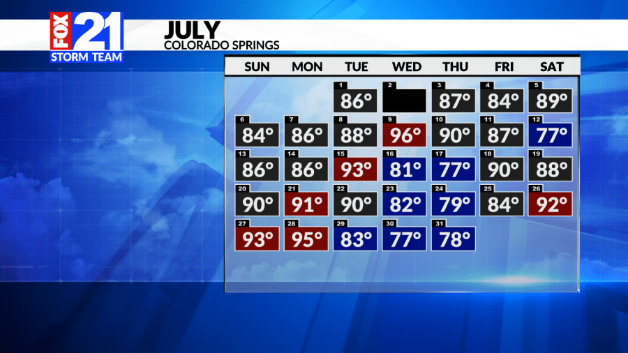
The calendar above illustrates the daily high temperatures for Colorado Springs throughout July. Gray shaded days represent highs that were within 3 degrees of the climatological average or essentially “near normal.” Red highlights indicate days with above-average temperatures, while blue represents cooler-than-normal days.
What stands out most is that more than half the month fell within the average range, which was 17 out of 31 days, to be exact. A few notable outliers occurred, largely driven by upper-level synoptic patterns. Toward the end of the month, a funnel of dry air led to a late-July warming trend, while at some points in the month, monsoonal moisture brought increased thunderstorm activity and rain chances, contributing to the cooler, blue-shaded days.
Rainfall in Colorado Springs during July tells an interesting story. While daily afternoon thunderstorms were common, driven largely by diurnal heating and typical summer patterns, measurable rainfall was actually limited.
Only 11 of the 31 days recorded measurable precipitation, making the month’s rain more sporadic than it may have felt. Below is a breakdown of the total rainfall observed throughout the month.
Just a short trip south down I-25, Pueblo experienced its own version of July’s dynamic weather.
While the overall story may sound similar to Colorado Springs, with hot afternoons and scattered thunderstorms, the day-to-day patterns in Pueblo played out quite differently. From temperature trends to storm timing, the city saw its own unique rhythm throughout the month.
The calendar uses the same color criteria as before: gray shading indicates temperatures near the climatological average, red marks above-average days, and blue represents below-average days.
Notably, several days reached triple-digit highs, along with multiple upper-90s, highlighting just how intense the heat was at times. The highest temperature recorded in Pueblo was a scorching 103 degrees on July 9th; quite a memorable heat spike.
Did Pueblo get much relief from the heat in terms of measurable rainfall? Not quite. Only 11 of the 31 days saw measurable precipitation. The most significant stretch of rain occurred from July 22nd through the 25th, when monsoonal moisture dominated the region and flash flood watches were issued, resulting in a notably wet week. The wettest single day of July recorded 0.80 inches of rainfall.
Some refer to August as the “Sunday of Summer,” marking the winding down of the summer heat. However, the Climate Prediction Center (CPC), which analyzes large-scale climate trends from a probabilistic standpoint, currently projects above-average temperatures for this region!
This suggests that summer warmth (and active weather) may continue for several more weeks before the season truly begins to cool. Whatever the month of August brings, the FOX21 Storm Team has you and the weather covered!

