Cold air is lurking north of Colorado and brings a blast of Arctic air to southern Colorado. Warm weather will quickly transition to frigid, wintry weather as an active pattern builds in early week. High temperatures will drop by around 50 degrees by Wednesday.
After a mild start to Monday, the first of several systems will start to impact the region. We’ll have more clouds in place and winds increase as a cold front moves across the area.
A Fire Weather Watch is posted Monday morning – evening ahead of the cold and snow. Warm afternoon temperatures, combined with gusty winds and dry surface fuels, will be favorable for a spark to spread. Strongest winds will be along/south of Hwy 50, stretching from Pueblo to Trinidad on I-25.
By Monday night, the front swings through and cold air surges in quickly. Snow showers will start to develop over the Palmer Divide north to Denver, with snow becoming heavier into the mountains. Overnight and into early Tuesday, scattered snow showers increase along I-25.
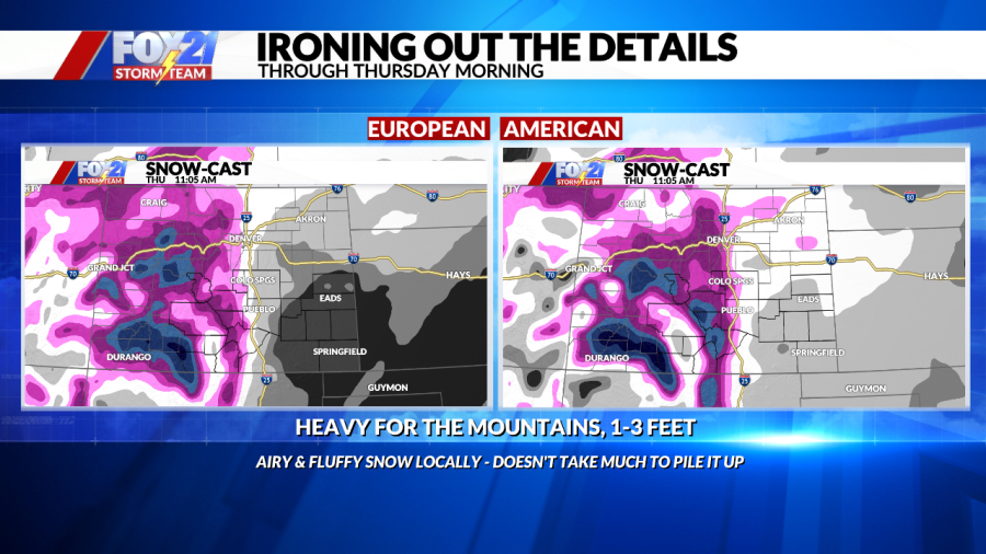
We won’t wake up to accumulations, but the Tuesday morning commute is when impacts start for the Front Range and most of I-25. Ongoing snow showers will cause lower visibility and with very cold temperatures already in place, snow will start to stick. Scattered snow continues through Tuesday and Tuesday night. This is going to be a big mountain storm with 1 to 2 feet of snow, even higher totals in the San Juans!
Keep in mind these totals can chance and we will continue to update them as we track the storm.
There will be a pretty sharp gradient in where snow cuts off, so areas just east of the Interstate see significantly less snow compared to the Front Range and I-25. The far eastern plains won’t get much snow. It will be an airy snow so it won’t take much to accumulate.
Another wave will reinforce snow chances and frigid air on Wednesday. Snow totals will stack up more with scattered showers through the day. Snow will favor the same areas as the first wave, with highest impacts along I-25 and into higher terrain areas. The Front Range will deal with snow most of the day, with pockets of heavier snow at times.
Additional snow will accumulate into Thursday morning. Stay with us for the latest updates on totals.
Thursday morning will be another tough commute behind the fresh overnight snow, adding to the first round of accumulations. By mid-late morning, most of the snow will be tapering down for southern Colorado. Snow will linger over the mountains through the afternoon before clearing late Thursday.
In addition to the snow, Arctic air will bring a stretch of frigid temperatures. Morning lows will be sub-zero in many spots with temperatures only topping out in the teens.
Wind chill will make it feel blustery, especially Tuesday and Wednesday mornings. Wednesday will be the coldest day of the week before we slowly thaw out to end the week!

