Wednesday morning starts quiet but showers, and even a couple thunderstorms, will develop this afternoon and increase in coverage and become more intense Wednesday night. Travel conditions above 6,000′ will deteriorate overnight. It’ll keep snowing through Thursday!
For some areas below 4,500′ over the eastern plains we may not see snow stick at all with this storm – even on the grass! If we are going to get some snow on the grass out over the eastern plains it’ll probably come Friday morning…we’ll keep an eye on that chance over the next few days.
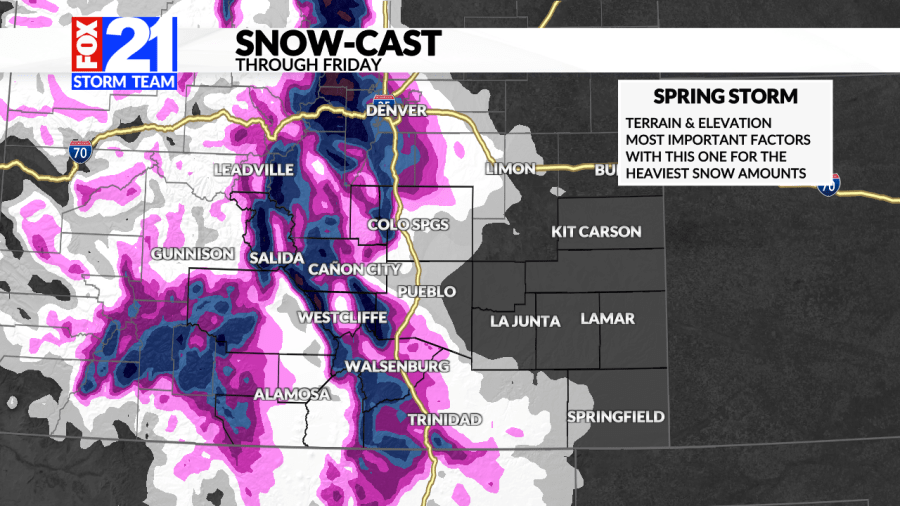
PIKES PEAK REGION/COLORADO SPRINGS
The Colorado Springs metro area is always the toughest place to figure out – we’re just at the right elevation for that. The southeast side of the metro likely ends up with something like 2-5″ of snow with the central part of town/downtown looking to be around 4-8″ and then heading north and west those amounts will pick up really, really quick!
SALIDA TO PUEBLO
Highway 50 through Fremont County and the mountains southwest of Pueblo are going to get rocked with this one. Some of our highest amounts will be found here over the northern Sangre de Cristo and Wet mountain ranges where more than two feet is expected.
Cañon City should be between about 4 and 10″ it’ll just depend on how quick we change over to snow. Some of what has fallen will melt during daytime hours too – we’re a tough spot to figure out with this one!
Pueblo is likely to see several inches of snow on the grass. It may rain for a good chunk of Wednesday night and finally change over to snow within a couple hours of sunrise on Thursday.
SOUTHERN MOUNTAINS/VALLEYS AND I-25
A significant spring storm on the way will bring more than two feet of snow to the Wet and Sangre de Cristo mountain ranges. I25 from Colorado City to Raton Pass will become challenging too as some areas will be between 10-16″.
The Wet Mountain Valley and the western half of the San Luis Valley will be shielded a bit and will be more likely to get 4-8″ of snow as sill central Las Animas County east of the Trinidad on highways 350 and 160.
PALMER DIVIDE / I25 to DENVER
The big hill that separates the South Platte River basin in northeast Colorado and the Arkansas River basin in southeast Colorado will get very heavy snow Wednesday night and Thursday morning and lighter snow into Thursday evening and perhaps Friday morning. Travel will be difficult between northern El Paso County and Denver on Thursday.

