(SOUTHERN COLORADO) — Snow, cold temperatures and wind are all on the way to southern Colorado this morning and afternoon a part of a strong arctic cold front. But the question remains… where’s the front and when can you expect it?
As the front arrives, temperatures will drop fast. We’re already starting to feel the sharp temperature drop on the northeast side of the Pikes Peak region as temperatures were in the mid-30s around 3:00 AM, now falling to the teens and 20s within an hour span. Most of us have already hit our highs of the day.
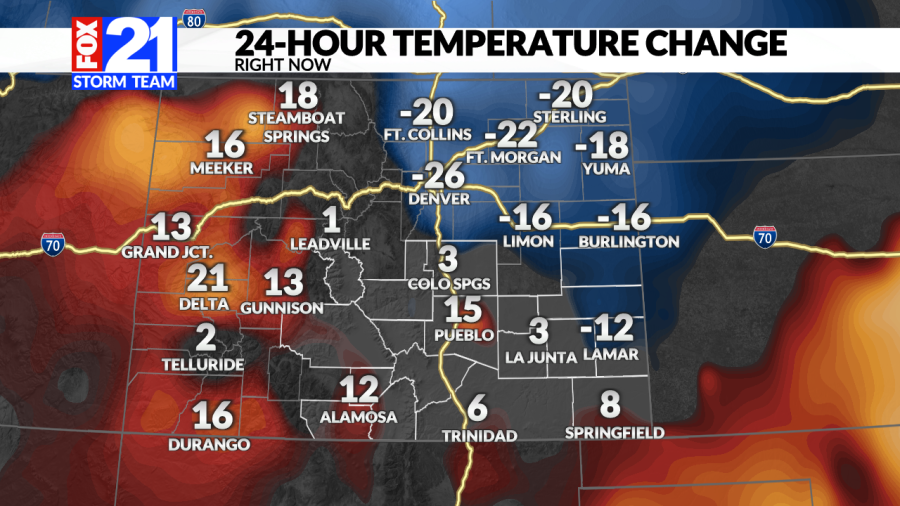
As the front drops in, temperatures are falling fast north to south. You can see the edge of the front on current temperature maps.
How fast you will feel the temperature drop is all going to depend on the timing of this cold front. Which as of this morning, has been moving fast across the region.
Along with the cold, wind will also begin to pick up, especially across the mountains through this afternoon.
Gusts up to 60-80 MPH will be likely through this afternoon across the mountains and foothills.
The wind tied with the cold air, will make it feel a LOT colder as you begin the day. Wind chills north of Colorado Springs are already down to 5 to 10 degrees below as of 4 AM.
With the cold and wind, snow showers will begin to develop. Making travel this morning and afternoon difficult at times across the Front Range. Even more difficult across the mountains where travel is expected to be difficult to impossible.
Darker blues indicating heavier snow band development
We expect some light snow in the Pikes Peak Region through the morning with some more intense bands or bursts moving across the area late morning-early afternoon.
As for the higher terrain south of Pueblo and the southern I-25 corridor during the late morning and afternoon, a few inches are possible for Pueblo if a burst or two hits us with much of the same across Teller County and northern El Paso County.
Travel across the Front Range begins to get tough after 8 AM
Depending on where some of the stronger snow bands set up, that will determine if you end on on the high end of ranges. 1-4 inches looks likely from Denver to the Pikes Peak region. Up to an inch from Pueblo south. Snow and wind start to taper down early Thursday morning.
Take us with you for detailed updates on where you are with our new FOX21 Weather App (Download it on Apple or Google Play).

