(SOUTHERN COLORADO) — A potent, and fairly well-organized system is expected to move through the region over the next couple of days. The system will bring numerous impacts to the area including:
High winds
Some winter weather
High fire danger
Air quality concerns
Currently, the center of the powerful low-pressure system is spinning over portions of Nevada and Utah. Notice the greens and blues in that direction, indicating some rain and snow. Out ahead of the system though, in Southern Colorado, we are preparing for very high winds and substantial fire concerns.
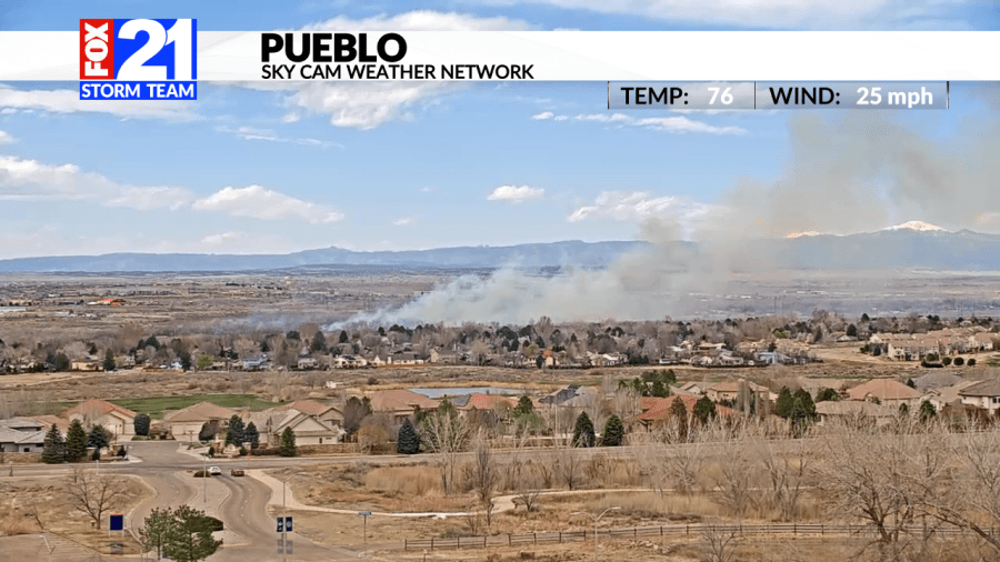
Red flag warnings are active for all of the Eastern Plains through Friday evening. Dry winds and very gusty conditions will lead to elevated fire concerns. Portions of the San Luis Valley are also under a red flag warning.
The fire danger is expected to continue into Saturday for much of the region. The fire weather watch will be active Saturday morning and evening. If dangerous trends continue, the watch will likely be upgraded to a red flag warning.
As far as winds go—they will also be a problem. This setup is looking particularly dangerous with models hinting at well over 80 mph wind gusts for portions of the higher terrain.
A high wind warning is in place for all counties in bright red above. That includes all of the I-25 corridor and much of our mountains pushing west. The warning is active through Saturday and Sunday morning. A high wind watch is also in place for portions of the I-70 corridor out east through Sunday afternoon.
Right now, it appears that we may see two potentially damaging rounds of wind:
Saturday morning
Saturday afternoon through Sunday morning
Both events are concerning, but the second round, later on Saturday, will potentially be even stronger. The I-25 corridor may very well see wind gusts 60+ mph and the higher terrain may see gusts 80+ mph. Be sure to secure loose objects and plan on difficult travel for North to South oriented roads (I-25).
The wind, coupled with the dry conditions, will of course help encourage dangerous fire weather should a fire start. Winds gusting at these speeds may make fire control extremely difficult so take extra care the next couple of days.
Strong winds blowing through the San Luis Valley will encourage blowing dust to develop. This has prompted an air quality alert from the National Weather Service. The alert goes through Friday evening.
On top of the fire and wind, we also are watching some winter weather for our highest elevations.
Winter weather advisories are in place for a few of our mountain peaks. In general, the advisories go through Saturday afternoon and evening. Winter weather at the lower elevations will be a bit more difficult to come by. Warm air and warm ground temperatures will lead to very little accumulations (if any).
Snow will start for the higher terrain out west late Friday night and on into Saturday morning as the potent low-pressure system slides through the area.
For Saturday morning and afternoon, this is what Storm-cast is keeping an eye on. Notice the greens right next to the blues for the lower elevations; this could lead to more of a rain/snow mix and might be a bit of a toss-up depending on if that freezing level can get close enough to the ground.
Snow totals will not be overly impressive this time around. The main impacts will be for wind and high fire danger. Nonetheless, small accumulations will be possible for our mountains.
Temperatures over the next couple of days will also fluctuate a bit in response to this system.
Highs on Saturday will be a bit cooler before rebounding rather quickly on Sunday. Highs near Lamar and portions of Eastern Plains will get quite close to 70 degrees for the second half of the weekend.
Spring is certainly here with this chaotic and windy storm system! Be sure to check back in with the FOX21 Storm Team for future updates.

