DENVER (KDVR) — Fire management of two Colorado blazes will be turned over to Type 3 Incident Management Teams on Wednesday as the fires grow in Eagle and Chaffee counties.
The two fires are called the Derby Fire, located in Eagle County near Garfield County, and the La Plata Fire, located in Chaffee and Lake counties in the Pike-San Isabel National Forests & Cimarron and Comanche National Grasslands managed by the National Forest Service.
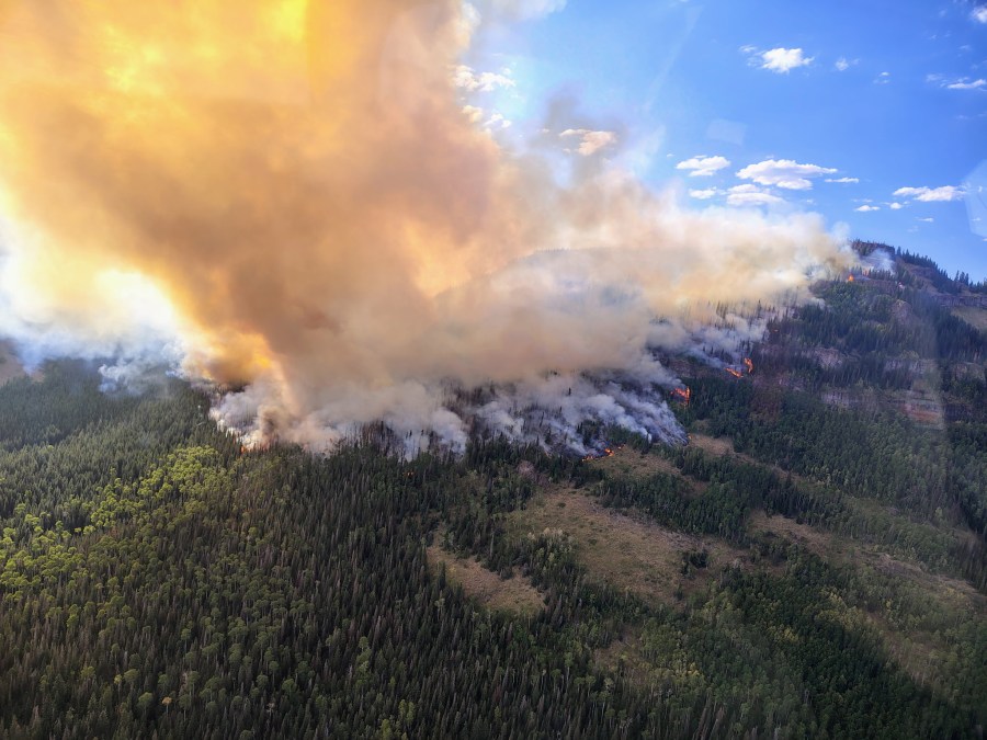
Derby Fire doubles in size Tuesday with hot temperatures
The Derby Fire was ignited by lightning on a “steep cliff above the West Fork of Red Dirt Creek” on Sunday morning, which is also when four smoke jumpers responded, according to the U.S. Forest Service for White River National Forest. The area is in northwestern Eagle County, north of Interstate 70 and about 15 miles north of Dotsero.
On Tuesday, the fire grew to an estimated 245 acres as activity picked up as temperatures rose throughout the day. It was about 50 acres at the start of the day, marking about a 390% increase.
Eagle County issued a pre-evacuation notice for the fire, but there is no immediate threat to structures, according to the U.S. Forest Service and Eagle County emergency officials.
An evacuation map can be found here, which is also searchable. Livestock and animal support can be found by calling the CSU Extension at 970-471-8043.
To support firefighter safety, the White River National Forest closed a portion of its lands to the public within the Blanco and Eagle-Holy Cross Ranger Districts.
The closure starts north of Sweetwater Lake, follows the forest boundary north and east to the intersection of the Derby Loop Road (County Road 39), following Middle Derby Creek northwest to Island Lakes; then, south following the Island Lakes Trail (#1842), the W Mountain Trail (#1817), the Turret-Crescent Trail (#2269) and the Turret Creek Trail (#1838) back to Sweetwater Lake. The forest closure map can be found here.
On Wednesday, the Northern Rockies Complex Incident Management Team 3 will assume command of the fire.
La Plata Fire believed to be human-caused
The La Plata Fire sparked on the border of Chaffee and Lake counties in the Pike-San Isabel National Forests & Cimarron and Comanche National Grasslands, which is managed by the National Forest Service.
The fire started around 5:45 p.m. on Sunday, Aug. 17, about 4 miles west of Twin Lakes in the Leadville Ranger District.
According to Inciweb, a government website for fire reporting, the 45-acre fire has air and ground resources working to quell and contain, but current containment is 0%.
There were approximately 32 personnel working on fire suppression, and a Colorado State Type 3 Incident Management Team was slated to take over command on Wednesday.
Crews asked motorists to avoid Highway 82 in the area while crews are working, and also noted that deploying drones near the fire causes air resources to be grounded due to safety concerns.
Chaffee County officials have not issued any evacuation or pre-evacuation orders, but the local government is urging people to avoid the area.

