(SOUTHERN COLORADO) — You may hear the term “blizzard conditions” tossed around when Colorado’s winter weather rears its head, but did you know there are measurable differences between a blizzard and a snow storm?
According to the FOX21 Storm Team, certain conditions must be met for a storm to be classified as a blizzard. The storm that’s rolling through Colorado starting Monday night, March 3 will qualify as a blizzard… sort of. Only portions of the storm will meet the criteria of a blizzard, and others in the region will be spared, though you might still see some pretty severe weather even if you’re not in the blizzard conditions.
For a storm to be called a blizzard, these conditions must be met:
It must be snowing
There must be winds 35 mph or above for at least three consecutive hours
Visibility must be reduced for three consecutive hours to a quarter of a mile or less
Essentially, whiteout conditions must be present for a sustained period of time to constitute a blizzard, which obviously, makes travel difficult if not impossible.
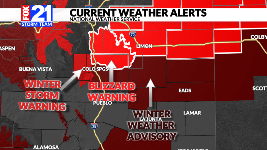
Courtesy: FOX21 Storm Team
As of Monday, a Blizzard Warning is in effect for northern El Paso County up to Castle Rock and parts of Douglas County all the way through the I-70 corridor. In addition to Blizzard Warnings, Winter Storm Warnings are in effect as well as High Wind Warnings.
Winds overnight Monday into Tuesday are projected to be anywhere from 40-50 mph up to 70 mph or more, according to the National Weather Service. Large amounts of snow are expected, though it will be nearly impossible to get an accurate measurement of snowfall due to those winds. Expect snow drifts and low visibility to cause extremely hazardous driving conditions in the warned areas.
The FOX21 Storm Team also said we are expecting a phenomenon called a “snow donut,” in which some places will see large amounts of snow, while others may not. Cañon City, Pueblo, La Junta, and Lamar will see hardly any snow, if at all.
Meteorologist Robert Hahn explains the “snow donut” effect, wherein some areas see high snowfall totals while others nearby see hardly any.
While those areas won’t see much snow at all, their not-so-distant neighbors to the north and south could see anywhere from a trace to 18 inches.
The biggest story will be the blowing snow. If you have plans to travel anywhere included in the Blizzard Warning above, like the Palmer Divide, the Gap, or I-70, you are strongly urged to reconsider. If you must travel, plan your route by checking road conditions ahead of time, build in extra time to take it slow, and ensure your car is packed with emergency gear like extra blankets and clothes, water, snacks, snow removal tools, de-icer, and road flares.

